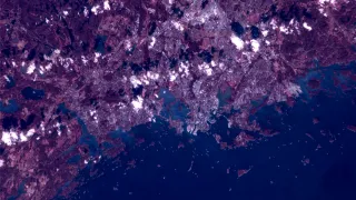
A picture of the Helsinki capital region taken by Hyperfield-1. Image: Kuva Space
Within six months, Hyperfield space missions will have two hyperspectral cameras stationed in the low Earth orbit (LEO). The hyperspectral camera technology, developed in collaboration between VTT and the Finnish company Kuva Space, can be used, for example, to monitor the status of fields and forests, measure air pollutants and make yield forecasts.
Finnish technology is being taken into the Earth’s orbit. Major advances have been made in developing hyperspectral camera in recent years. Due to their small size and low costs, the cameras developed by VTT open totally new opportunities for science and industry.
Within a short period of time, the hyperspectral camera technology co-developed by the Finnish company Kuva Space and VTT is being stationed in space on board two different satellites. The first camera was launched in August 2024 from Florida in the United States as part of Kuva Space’s own commercial space mission, Hyperfield-1A. Another Hyperfield space mission awaits in the beginning of 2025. This mission, Hyperfield-1B, is part of the European Space Agency’s (ESA) InCubed programme.
Kuva Space is a Finnish space technology company, which is building the world’s most extensive microsatellite constellation for accurate imaging of the Earth using hyperspectral camera technology. The cameras provide high-quality images, which are processed using AI, to serve as a basis for up-to-date information for various sectors.
The Finnish hyperspectral camera technology offers highly accurate data to serve the needs of agriculture, forestry, climate change mitigation and so on
Kuva Space’s remote sensing and imaging application is based on technology developed by VTT. In agriculture and forestry, it is used for purposes such as forecasting yields, improving food safety and managing the impacts of climate change.
The system is based on using hyperspectral cameras in the Earth’s orbit. They are constantly focused on the Earth’s surface and send highly detailed intelligence in almost real time down to Earth.
“This technology enables us to, for example, build an extremely precise image of the status of a field or a forest anywhere around the world every day of the year at a specific time,” says Antti Näsilä, Principal Scientist at VTT.
Hyperspectral cameras have almost a limitless amount of potential uses
The opportunities awarded by hyperspectral cameras are breathtaking! Its uses can include environmental monitoring, greenhouse gas emission monitoring, identification of mineral composition of asteroids and other complex materials, and different drone applications for the needs of, for instance, national defence.
“The hyperspectral camera technology offers a unique opportunity for accurate monitoring of the status of the seas. For example, we can detect algal blooming in its early stages, which helps us protect water systems and their ecosystems. This technology enables data-based decision-making to preserve the seas and biodiversity.” Tuomas Tikka, Kuva Space Co-founder and CTO – Technology and Engineering
Hyperspectral cameras can capture their targets on various wavelengths of the narrow band, enabling closer analysis than conventional cameras. Hyperspectral cameras can differentiate between different materials and analyse their chemical and physical properties at a very high accuracy. This kind of data will soon become extensively available for operative applications.
The development of hyperspectral cameras continues all the time. Their optical performance is improving to cover more and more wavelength ranges with an enhanced image quality.


